This Week in Disasters

An aerial view of flooding in Shiprock, N.M., on the Navajo Nation. Source: Navajo Nation Police Department
An NC State model can flag which neighborhoods will need rescue before a hurricane hits.
Welcome back to This Week in Disasters! This newsletter combines expert perspectives with a weekly roundup of upcoming threats, recent natural disasters, and available survivor assistance. If you're a Risk, Insurance, Employee Assistance, or Emergency Management professional (or you're just really curious about weather in the United States!), you're in the right place.
If you want to receive exclusive news, updates, and job postings, sign up for This Week in Disasters here.
Major Disasters of the Last Week
The San Juan River at Pagosa Springs, Colorado, crested at 15.02 feet early Friday, October 23, the second-highest level on record there behind the 1911 flood. About 540 homes were damaged in Archuleta County, and crews ran 40 rescue missions that brought 38 stranded people to safety. Gov. Jared Polis declared a disaster emergency for 12 counties, and the Colorado Department of Transportation has asked for $65 million in federal emergency relief for highway repairs. Read more. |
Downstream, the San Juan River broke its 1909 flood record at Farmington, New Mexico, and floodwater damaged roughly 500 homes in the Shiprock area of the Navajo Nation and put about 1,500 residences under evacuation orders. President Trump signed a federal emergency declaration on October 26 for San Juan, Cibola, Rio Arriba, and Sandoval counties and five tribes and pueblos. Gov. Michelle Lujan Grisham estimates recovery will cost $200 million to $300 million. Read more. |
An EF-1 tornado with peak winds near 110 mph touched down in midtown Santa Fe at 7 p.m. on Saturday, October 24, damaging 10 homes along a 1.4-mile path. No injuries were reported, and Mayor Michael Garcia declared a disaster emergency on Monday, saying recovery needs are beyond the city's immediate capacity. Read more. |
Forecasted Risks to Watch for the Next Week
Flood Watches cover most of Arizona from Saturday evening into Monday morning. NWS forecasts up to 3 inches of rain in Sedona, Flagstaff, Prescott, and Payson, with the heaviest falling Sunday on ground still soaked from last week's storms.
More rain and mountain snow reach the flooded Four Corners this weekend. NWS forecasts 1 to 3 more inches of rain for southwest Colorado, mostly Sunday morning through Monday, and more than a foot of snow above 9,000 feet.
A storm system crosses the central U.S. Monday through Wednesday. WPC expects gusty winds across the Plains on Monday and locally heavy rain along the Mississippi Valley before storms push toward the East Coast by Wednesday.
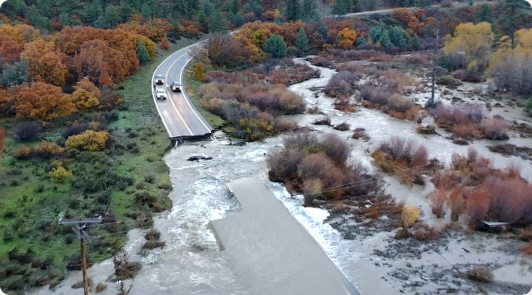
An aerial view of flood damage on Colorado 151 between Ignacio and Pagosa Springs. Source: Colorado Department of Transportation
Disasters in the Headlines
"Lawmakers question FEMA's claim that states may need to handle disasters on their own"
"A 'Green Army' is out to thwart El Niño flooding"
"New Mexico lawmaker seeks to scrutinize insurers’ ‘catastrophe models’ used to deny home coverage"
PRO PERSPECTIVE
Machine Learning Can Flag Who Will Need Rescue Before a Hurricane Hits

Ben Rachunok, an assistant professor in the Edward P. Fitts Department of Industrial and Systems Engineering at NC State University, co-authored research that can point to the neighborhoods most likely to need hurricane rescues before the first 911 call. His work carries a lesson for emergency managers: the best guide to where rescue crews should go comes from records kept before a storm and after it. The reports that pour in during the storm are too incomplete and unreliable to steer by.
Rachunok grew up in Wilmington, North Carolina, where one hurricane left his family's second-floor apartment untouched and flooded out his friend Tyler's family downstairs. One floor decided who lost everything. Differences that small are what his research tries to see coming.
During the storm, information runs out first
Hurricane Harvey showed how fast responders lose track of who needs help and where. Houston's 911 call centers were overwhelmed, and responders rescued 122,331 people. Co-author Brandon McConnell, director of NC State's Master of Engineering Management program and an associate research professor, describes crews arriving from all over to work from a map of a place they've never been, with reports pouring in and no way to sort valid from invalid. "You're drinking from a fire hose: too much information, and at the same time very little understanding," he says.
The requests that did get through were thin. Half the team's rescue records came from a Google form. A two-word "need help" counts the same as a report that the water is one foot below the door, and people who couldn't get online, likely the most vulnerable, never appear at all. Without a better map, Rachunok says, crews fall back on checking everywhere by helicopter and boat.
Before the storm, the signal is already on file
The better map starts with records that predate landfall. In "Anticipating Household Rescue Demand in Hurricanes Using Socio-Demographic Data and Machine Learning," published in September in the International Journal of Disaster Risk Reduction, Rachunok, McConnell, Patrick Leavitt, and Fred Livingston trained a machine learning model on those rescue requests, census data, and pre-Harvey FEMA flood insurance claims across 1,165 Houston-area census tracts. The model ranks a tract that needed rescue above one that didn't about 73% of the time.
Flood insurance history was the strongest predictor. Rachunok hypothesizes that a claim marks a household that lives with flood risk and already turns to institutions for help. Spanish-speaking residents and households of four or more sharing one vehicle came next, and tracts with many single parents or seniors living alone hit tipping points where need for outside help jumped. Leavitt, the first author and an active-duty Coast Guard officer, saw the same pattern in who called: households that knew right away they couldn't easily leave. "The things that lead to more or less rescues are stuff you could have figured out in advance," Rachunok says.
A map built early changes the first 48 hours
That pre-storm map gives Incident Command a starting picture of where limited ground, maritime, and aerial assets will do the most good, before field reports arrive. It also helps tactically. A helicopter returning from one sector can detour over a high-risk tract instead of flying straight across a low-risk one.
The decision that needs making before landfall is which mistake to accept. Rachunok knows which one he fears. "I don't want to produce a statistical model that says there's an 80% chance that nothing's going wrong here, and then there was something going wrong," he says. McConnell says Leavitt's Coast Guard experience shaped how the team weighed missed rescues against false alarms. In the paper, lowering the decision threshold raised the share of rescue tracts caught from 50% to 76%, while false alarms rose from 22% to 40%. Agencies should pick their setting in planning, not mid-response.
After the storm, the record trains the next model
Every one of those gains depends on what goes into the model. "There's no magic," Rachunok says. "There's nothing that's going to do better than what we've put into it." A machine learning model learns patterns from past events and repeats them. It can't learn from a rescue nobody logged, so the gaps in one storm's record become blind spots in the next storm's forecast. That makes the after-action record as important as the forecast itself. The severity model lands within one category of the right answer 78% of the time but catches only one in four of the hardest-hit tracts. Part of the problem is that a quiet tract looks the same whether no one needed help or crews got there first. A community can be highly vulnerable and highly resilient at once, and today's data can't tell the difference. Closing that gap takes data only emergency managers have: a post-event breakdown of what they saw and what they did, ideally hour by hour, so researchers can tell a quiet tract from a well-served one. Rachunok admits it's a big ask. He calls it onerous enough that his team has never requested it.
Rescue maps belong in rebuilding decisions
The after-storm record has a second use. Under many North Carolina DOT policies, Rachunok notes, recovery money rebuilds exactly what was there. He grew up with a different rule: in his beach town, flooded houses went back up on stilts. A neighborhood that needs rescue every storm ties up crews that could reach someone else. "My best option for improving during-disaster rescues is actually preventing these people from needing to be rescued at all," he says. That can mean a flood-protected shelter or a community center in the tract that keeps calling for boats. Each one protects the people who live there and frees crews to reach more people in the next storm.
Active Federal Declared Disasters and Deadlines
There is usually a 60 day window to apply for help after a disaster is declared. The following disasters are actively taking applications from survivors for financial support. To apply, survivors can visit DisasterAssistance.gov or call the FEMA Helpline at 1-800‑621‑3362.
Florida - Hurricane IsaiasSTATUS Major Disaster declared October 27, 2026; IA applications accepted in eligible counties until December 28, 2026 AFFECTED COUNTIES Bay, Escambia, Gulf, Holmes, Okaloosa, Santa Rosa, Walton, Washington |
West Virginia - Severe Storm and FloodingSTATUS Major Disaster declared October 7, 2026; IA applications accepted in eligible counties until December 7, 2026 AFFECTED COUNTIES Fayette, Harrison, Kanawha |
Wisconsin - Severe Storms and TornadoesSTATUS Major Disaster declared October 7, 2026; IA applications accepted in eligible counties until December 7, 2026 AFFECTED COUNTIES Forest, Outagamie, Vilas, Winnebago |
Guam - Super Typhoon BaviSTATUS Major Disaster declared October 7, 2026; IA applications accepted in eligible counties until December 7, 2026 |
New Mexico - Severe Storms and FloodingSTATUS Major Disaster declared October 7, 2026; IA applications accepted in eligible counties until December 14, 2026 AFFECTED COUNTIES Zuni Pueblo (Indian Reservation) |
Ohio - Severe Storm, Straight-line Winds, Tornadoes, Flooding, and LandslidesSTATUS Major Disaster declared October 2, 2026; IA applications accepted in eligible counties until December 1, 2026 AFFECTED COUNTIES Clermont, Franklin, Hamilton, Licking, Morgan, Muskingum, Perry |
South Dakota - Severe Storms, Straight-line Winds, and FloodingSTATUS Major Disaster declared September 1, 2026; IA applications accepted in eligible counties until November 30, 2026 AFFECTED COUNTIES Oglala Sioux Tribe of the Pine Ridge Reservation |
Hawaii – Kona EarthquakeSTATUS Declared September 1, 2026 for the May 22 magnitude 6.0 earthquake. FEMA Individual Assistance deadline November 1, 2026. Assistance includes temporary housing, home repair, and repair or replacement of water catchment systems. SBA low-interest loans available through the MySBA Loan Portal or 1-800-659-2955. AFFECTED COUNTIES Hawaii |
Sign up for This Week in Disasters here.


