Are you a disaster survivor looking for help? Click here
This Week in Disasters
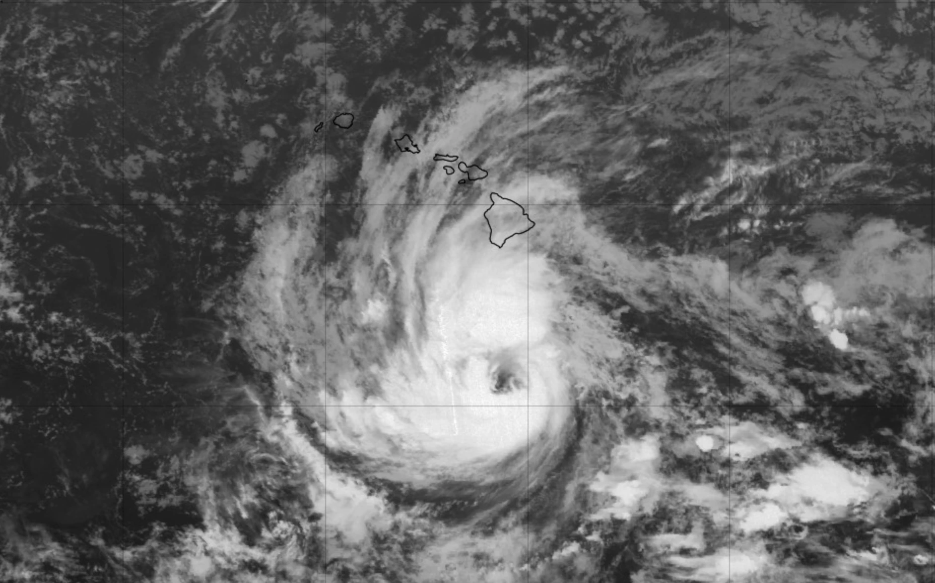
Hurricane Nolo. Source: NOAA
Plus, everyone wants to flatten a disaster map. This week's Pro Perspective wants all the quirks.
Welcome back to This Week in Disasters! This newsletter combines expert perspectives with a weekly roundup of upcoming threats, recent natural disasters, and available survivor assistance. If you're a Risk, Insurance, Employee Assistance, or Emergency Management professional (or you're just really curious about weather in the United States!), you're in the right place.
If you want to receive exclusive news, updates, and job postings, sign up for This Week in Disasters here.
Major Disasters of the Last Week
An estimated 4.5 to 5 inches of rain fell on Harlan County in under two hours overnight on September 21, sending flash floods through the communities of Coxton, Brookside, and Ages. Residents were forced from their homes and water rescues continued through the night; homes, vehicles, roads, bridges, and waterlines were damaged. Read more. |
Flash flooding returned to southeast Ohio on September 21 as the Hocking River rose nearly 15 feet in 48 hours, prompting multiple water rescues across Athens County, where communities like Trimble and Glouster were still recovering from August's floods. Gov. Mike DeWine declared a state of emergency for 19 counties the next day, directing state agencies to support the cleanup. Read more. |
More than 5 inches of rain fell across parts of New Mexico on September 22 and 23, triggering water rescues, road closures, and at least one daily rainfall record as an unusual surge of moisture opened the fall. Crews worked flooded arroyos in Albuquerque while officials postponed events and closed roads, and rain was still falling midweek. Read more. |
Forecasted Risks to Watch for the Next Week
Hurricane Nolo is forecast to become a major hurricane Saturday as it passes south of Hawaii's Big Island. A Hurricane Watch is in effect for Hawaii County, with 15 to 30 inches of rain forecast for the island's eastern and southern slopes (isolated 35) and forecasters warning of catastrophic, life-threatening flooding and mudslides.
A strengthening coastal low will bring heavy rain, gusty winds, coastal flooding, and rip currents to the East Coast into the weekend. The heaviest rain reaches the Northeast Saturday as the low centers near Long Island.
Flash flood risk continues from New Mexico into the southern and central Plains through Saturday as tropical moisture streams over soils already saturated by days of rain. Even modest additional rain can trigger flash flooding across much of New Mexico.
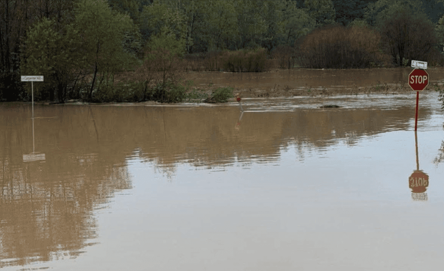
Flooding in Ohio. Source: Meigs County Emergency Management Agency
Disasters in the Headlines
Atlantic goes without a hurricane through Sept. 21, breaking 112-year record
What’s the Best Way to Fight Wildfires? All of Them.
Post-Disaster Gentrification’ Proliferates in Florida Towns as Costs Soar Following Hurricanes
What It Takes to Financially Survive a Disaster, According to Hurricane Helene Survivors
New Tool Helps Responders ID Highest-Risk Areas for Post-Hurricane Rescue Efforts
PRO PERSPECTIVE
The Best Data Never Left the Neighborhood Block

Daniel Starosta grew up on hurricanes in South Florida, before he knew disaster management was a profession. Nobody taught him any of it. He knew which of his friends' houses lost power every year and which ones didn't. "Now I look at them at 35 and I'm like, ah, social vulnerability," he says. Every community holds knowledge like that, and almost none of it survives contact with an official map. His work exists to fix that loss.
Starosta founded Brackish Projects, an applied research lab, after a career spent watching organizations operate without that local knowledge. He started in product design with disaster relief projects on the side, then went full time into emergency response and United Nations humanitarian work, including graduate research in Puerto Rico after Hurricanes Maria and Fiona and the 2020 earthquake. "The gap between what organizations want to offer communities and what communities actually need is a giant hole in the middle," he says. Plenty have tried to close it; what is missing, he finds, is the willingness or the research depth to explain it.
Keep all the quirks
Puerto Rico is where the gap turned into a project. “Disasters are about more than just physical risk, they’re about social risk,” he says. Conditions there vary at a literal block-to-block level, in ways that read as noise to outsiders and as obvious fact to anyone local. No map he could find preserved that texture. "Everybody wants to flatten a lot of that," he says. "I take the full opposite approach. I want all the complexity. I want all the quirks."
Three layers deep
A Brackish map runs three layers deep: vulnerability, partners, and narrative. The vulnerability layer turns stories into numbers. In California, he helped develop a social vulnerability index for farm laborers in wildfire conditions, where the real work was finding proxy variables for things no census asks: a household where one spouse is documented and the other is not, working for an employer who ignores unsafe conditions, or turning a myriad of qualitative conditions in measurable data. On a World Bank project in Bhutan for glacial lake flooding just like Nepal recently experienced, he handed the government some 500 survey questions, then a process for converting the answers into a hundred quantitative variables overlaid on known physical hazards. New community, new hazard, same process.
The partner layer tracks local disaster relief and humanitarian organizations, because that roster goes stale faster than the paperwork. Groups that formed or won million-dollar grants after Maria are still read as ready partners on paper, while the money is long spent and the people who ran them are back at full-time jobs. When a colleague doing post-eruption work in the Philippines could not figure out which organizations held the data he needed, Starosta's partner map already listed them.
The narrative layer is built from composite life stories, assembled from real events, that trace how lives get upended after a disaster and why some don't. Starosta studied archaeology and has done post-disaster heritage preservation work, and it shows. "Culture is infrastructure," he says. "We just don't give it credit for it." He calls this the most "viscerally recovery focused" part of the map, "because it tells you the next several years of how people are going to struggle." At the country scale it becomes infrastructural history. When his Venezuela map could not keep pace with Humanitarian OpenStreetMap volunteers, he wrote 80 years of the country's infrastructure decisions instead. "How are we going to build a 10-year recovery plan that doesn’t understand how we got here?" he asks. Much of Caracas is in heavy trouble. Chacao, where the government money has gone for the last 35 years, is not. A flat map might route aid there anyway.
Ask before the storm
None of it can be assembled mid-crisis. People in the middle of a disaster cannot hand a researcher the story of their lives, and "asking them for that information is a crazy choice." The interviews, and the trust they require, happen early. "I consider this more of a preparedness effort than anything else," he says. He builds the map under blue skies so responders and communities can use it under grey skies. “Even though I initially envisioned it to help alleviate some of the issues from when I was doing response work,” he says “the goal is also for communities to use the information to advocate for themselves.”
Off the website, onto the ground
In Puerto Rico, communities can already use his map to plan the next few years of their own organizations, and to walk into their mayor's office pointing at the specific reasons it says they are struggling. Next is a US-focused map; the first two took several months each. He plans to build the following ones directly with communities: VOADs, local governments, school youth groups. "This is not supposed to be a project that sits on my website and I share with five friends," he says. He grew up knowing things no official map recorded, and the work is making sure the next map does. How he gets there hasn't changed. He shows up to the places and asks people there. "It's so much stronger if I am actually on the ground, talking to people asking ‘tell me your story.’ And I have to earn every one, even if it’s mucking and gutting a house alongside them."
Active Federal Declared Disasters and Deadlines
There is usually a 60 day window to apply for help after a disaster is declared. The following disasters are actively taking applications from survivors for financial support. To apply, survivors can visit DisasterAssistance.gov or call the FEMA Helpline at 1-800‑621‑3362.
Louisiana - Tropical Storm ArthurSTATUS Major Disaster declared June 30, 2026; IA applications accepted in eligible counties until October 1, 2026 AFFECTED COUNTIES Avoyelles, St. Landry, St. Tammany, Terrebonne |
West Virginia - Severe Storm, Straight-line Winds, Tornadoes, Flooding, Landslides, and MudslidesSTATUS Major Disaster declared August 3, 2026; IA applications accepted in eligible counties until October 3, 2026 AFFECTED COUNTIES Lewis, Upshur |
Northern Mariana Islands - Super Typhoon BaviSTATUS Major Disaster declared August 3, 2026; IA applications accepted in eligible counties until October 3, 2026 AFFECTED COUNTIES Rota (Municipality) |
Mississippi - Tropical Storm ArthurSTATUS Major Disaster declared August 3, 2026; IA applications accepted in eligible counties until October 3, 2026 AFFECTED COUNTIES Hancock, Harrison, Pearl River, Stone |
Indiana - Severe Storm, Straight-line Winds, Tornadoes, and FloodingSTATUS Major Disaster declared August 25, 2026; IA applications accepted in eligible counties until October 25, 2026 AFFECTED COUNTIES Hancock, Harrison, Pearl River, Stone |
Hawaii – Kona EarthquakeSTATUS AFFECTED COUNTIES Hawaii |
Oglala Sioux Tribe – Severe Storms, Straight-line Winds and FloodingSTATUS Declared September 1, 2026. Individual Assistance available across the Pine Ridge Reservation. No application deadline has been published yet; check DisasterAssistance.gov. |
Sign up for This Week in Disasters here.