This Week in Disasters
Source: Texas A&M Forest Service
Plus, what really matters about El Niño-Southern Oscillation (ENSO) and the importance of preparedness no matter the forecast
Welcome back to This Week in Disasters! This newsletter combines expert perspectives with a weekly roundup of upcoming threats, recent natural disasters, and available survivor assistance. If you’re an HR, Risk, Insurance, Employee Assistance, or Emergency Management professional (or you’re just really curious about disasters in the United States!) you’re in the right place.
Major Disasters of the Last Week
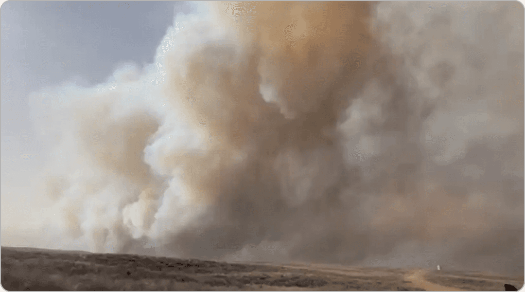
Active wildfires in Texas near the Texas panhandle.The Lavender Fire in Oldham/Potter County has burned 12,000 acres and is 20% contained. The evacuation order for Valley De Oro was lifted. The 8 Ball Fire has burned 9,000 and is 40% contained. Read more. |
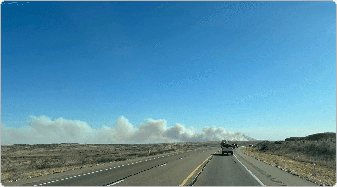
Active wildfires in Oklahoma near the Oklahoma panhandle.The Range Road Fire in Beaver County has burned 283,000 acres and is 15% contained. The Morning Fire started around 10:30am Thursday morning. It is located southeast of Boyd. An evacuation order was issued. The Stevens Fire in Texas County has burned over 12,000 acres and is 50% contained. The Side Road Fire in Texas County has burned almost 4,000 acres and is 60% contained. Read more. |
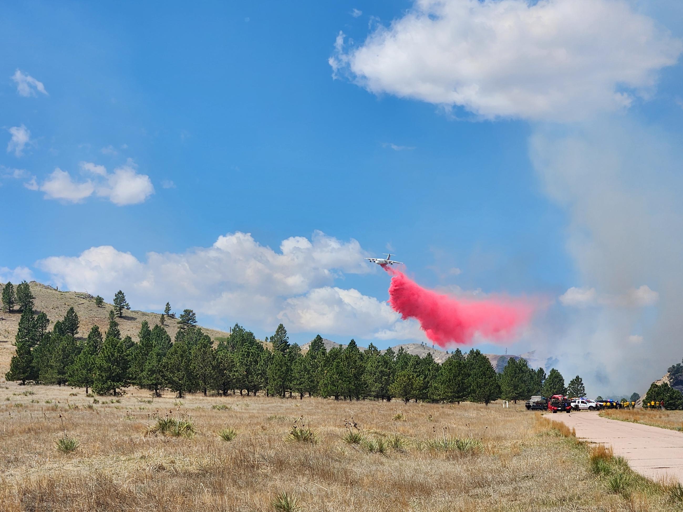
Two wildfires driven by wind in Coloradoprompted evacuation orders on Tuesday. No damaged structures have been reported this far. Read more. |
Severe thunderstorms produced several tornadoes, hail and powerful wind guststhat took down trees and damaged property across portions of southern Illinois and Indiana Thursday afternoon and into the evening. Read more. |
Forecasted Risks for Next Week
A potential nor’easter is expected to bring snow and freezing rain to the Northeast this weekend or early next week.
Critical fire weather continues into next week, especially in Northeast Colorado, Southwest Nebraska, Northwest Kansas.
Source: Oklahoma Forestry ServicesDisasters in the Headlines
Disasters in the Headlines
Trump administration restricts new FEMA disaster deployments during DHS shutdown
A massive climate resilience program is escaping Florida’s DOGE purge
How Los Angeles Is Reinventing Post-Disaster Rebuilding With Pre-Approved Home Catalogs
The Epicenter
COLUMN: What Can Be Done When FEMA Goes Quiet?
Homeland Security Today
PRO PERSPECTIVE
ENSO is a Signal. Preparedness is a Strategy.

Cheryl Nelson knew she wanted to be a meteorologist at nine years old.
“I was such a nerdy kid,” she says. After moving from Connecticut to Virginia, she became fascinated by the infamous I-95 rain snow line. “Is it going to be rain, sleet, freezing rain, snow? I would watch all the meteorologists on TV and I said, this is what I want to do. I want to help people plan.”
That instinct to help people plan has defined her career.
Nelson earned her meteorology degree from Penn State and worked up and down the East Coast in broadcast television. Over time, her focus expanded beyond forecasting to preparedness. She later worked as a Department of Defense contractor, helping run large scale disaster exercises where military and government teams trained against realistic disaster scenarios. “We would do fake newscasts with these fake disasters and see how they would respond as if it were real,” she explains.
In 2014, Cheryl was crowned Mrs. Virginia International, and she chose natural disaster preparedness as her platform. “As a meteorologist, what is our passion? To save lives and property.” She went on to launch Prepare with Cher LLC where she partners with companies and brands to strengthen their preparedness message, and also teaches weather hazard courses nationwide through FEMA’s National Disaster Preparedness Training Center.
That blend of forecasting, training, and community engagement shapes how she talks about terms often heard in the news, such as El Niño, La Niña, and hurricane risk.
First, she is careful about her lane.
“While I’m a meteorologist, I’m not a climatologist,” Nelson says. She relies on ENSO outlooks from NOAA’s Climate Prediction Center. ENSO, the El Niño Southern Oscillation, refers to recurring warming or cooling of the waters in the equatorial Pacific. El Niño means warmer than normal waters. La Niña means cooler than normal waters. These are not storms. They are slow moving climate patterns that affect the atmosphere over months to years at a time
Right now, NOAA indicates ENSO neutral conditions are likely through much of the summer, with the potential for El Niño to develop later in the year.
But Nelson is quick to challenge oversimplified headlines.
“There’s nothing where it’s because of [ENSO], there will be [extreme hurricanes] for sure,” she says. ENSO influences hurricane seasons, but it does not dictate them. “Every hurricane season is different. It just takes one storm to change everything.” Remember Hurricane Andrew that devastated parts of south Florida in 1992? That was an El Nino year.
That point matters for emergency managers watching seasonal outlooks. Even in a classic El Niño year, when increased wind shear can sometimes suppress Atlantic storms, Nelson warns against complacency.
“You’ve got to prepare for every season, every year, just the same,” she says
This year is especially complex. Currently, the first half of hurricane season is forecast to unfold under neutral conditions, not El Niño. Neutral does not provide the same potential wind shear protection sometimes associated with stronger El Niño events. At the same time, the Atlantic remains extraordinarily warm.
Warm water is fuel. A warmer atmosphere holds more moisture. That combination can allow storms to form more easily, intensify more rapidly, maintain strength longer, and produce heavier rainfall. Climate change has not altered the physics of El Niño itself, but it has changed the background conditions in which these patterns operate.
“The oceans are holding far more heat,” Nelson explains. “Even neutral years can still produce extreme weather because the entire climate system is more energetic.”
For resilience professionals, the takeaway is clear. ENSO shifts probabilities. It does not eliminate exposure.
Preparedness, in Nelson’s view, cannot wait for a forecast to firm up. She also reinforces the fact that despite the best computer models, forecasting the weather is predicting the future and remains an inexact science.
“We’re in February right now,” she notes in the interview. “Hurricane season runs June 1 to November 30 in the Atlantic Basin. What you want to start doing right now is getting your plan and disaster kit together, knowing your risk, and making sure you have the appropriate insurance coverage”
She highlights a common gap. Flood insurance is separate from most homeowners policies. Some states require additional wind coverage. “It’s up to you to know, do you live in a FEMA designated flood zone? Even if you don’t, it can still flood wherever it rains enough fast enough,” she says
Beyond insurance, Nelson emphasizes layered preparedness: generators purchased before shelves empty, home inventories documented with photos or video, evacuation zones understood in advance, and paper maps available if digital systems fail.
And she returns often to community preparedness.
“You and your neighbors may be your own very first responders following a disaster,” she says
For emergency managers and resilience leaders, that quote is more than a soundbite. It is a reminder that public messaging must translate climate signals into practical action. Neutral does not mean calm. El Niño does not guarantee predictability. And seasonal outlooks do not reduce the need for operational readiness.
Nelson’s core message is simple and consistent with her lifelong mission to help people plan:
ENSO still matters. But preparedness matters more.
Because in the end, “all it takes is one storm to make it a catastrophic hurricane season”
To learn more, follow Cheryl on social media @CherylNelsonTV and @PrepareWithCher and enter your email address to subscribe to her blog here.
Active Federal Major Disasters
There is usually a 60 day window to apply for help after a disaster is declared. The following disasters are still actively taking applications from survivors for financial support.
The following disasters are actively taking applications from survivors for financial support. To apply, survivors can visit DisasterAssistance.gov or call the FEMA Helpline at 1-800‑621‑3362.
Washington - Flooding (State Assistance)Information: Those whose homes were damaged by December's historic flooding should apply for in state assistance for their immediate needs. Impacted individuals should visit SAHelp.org and enter their zip code to start the process. AFFECTED COUNTIES King, Snohomish, Skagit, Whatcom |
Last Day to Apply for Individual Assistance: |
North Carolina - Flooding and Storm Damage from Tropical Storm ChantalSTATUS SBA disaster declaration approved July 26, 2025; applications open for residents and businesses in eight NC counties. The deadline to return economic injury applications is April 27, 2026. APPLY NOW AFFECTED COUNTIES Alamance, Caswell, Chatham, Durham, Granville, Orange, Person, Wake Counties |
Sign up for This Week in Disasters here.
Did you know we're hiring? Check out our open roles below.